4 July 2022 More Exploring of the region
Today is Bill’s Independence Day celebration of 20 years!!

A lot of rain around today too
Not to be daunted we still headed out to explore more of the region…
First stop The Chimney
Lots of things to see on the way too.,.

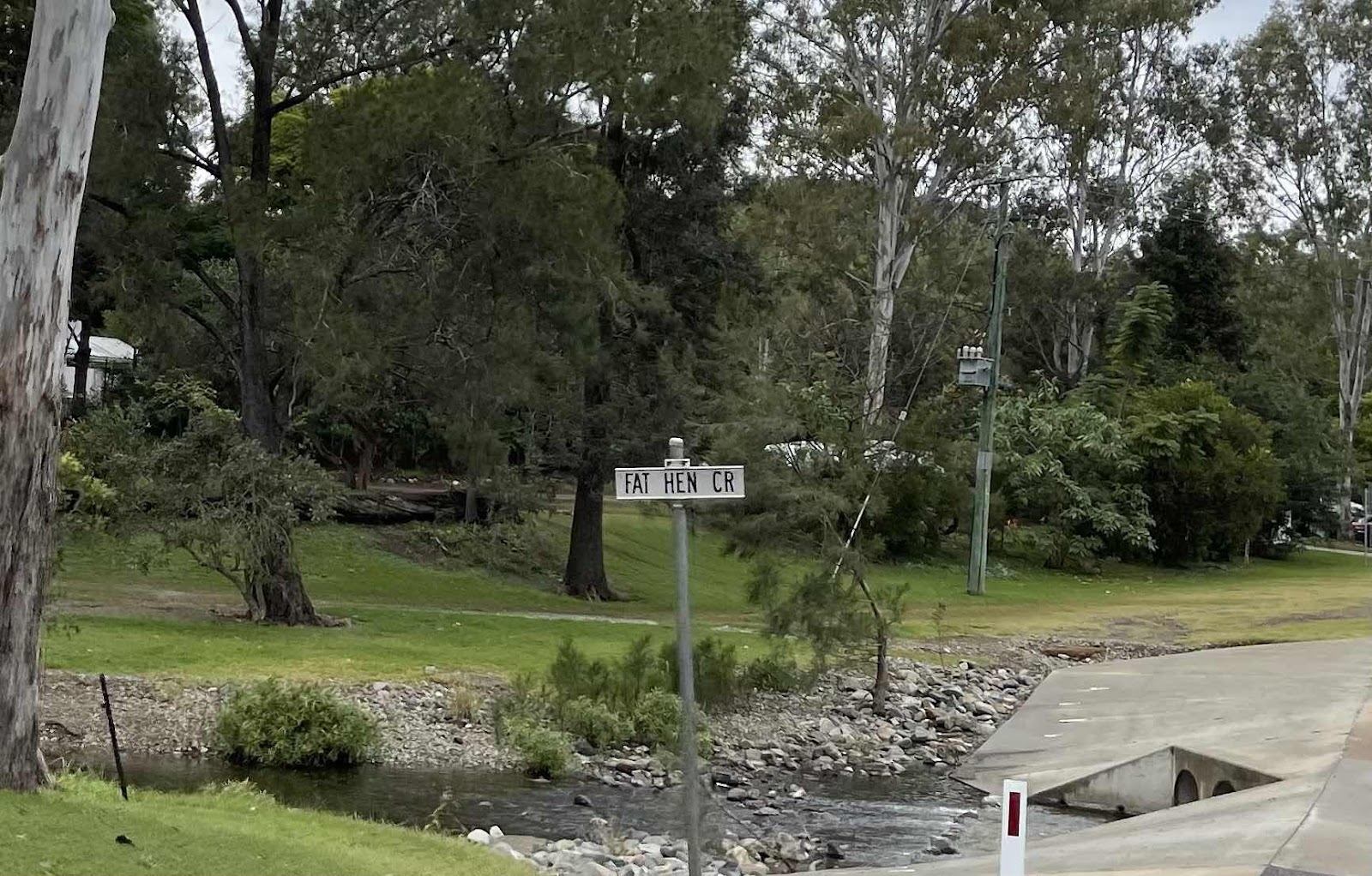

Fay Hen Creek that we crossed over several times


These cows were walking along beside the fence. There were more that look just the same with the pretty white markings on, that I took video of

I also took video of us splashing through the creek crossings, I did manage to catch the splash on this one through the open window and didn’t get wet

Came across this wash out where a temporary by pass road had been constructed

Finally we reached the end of the navigable road

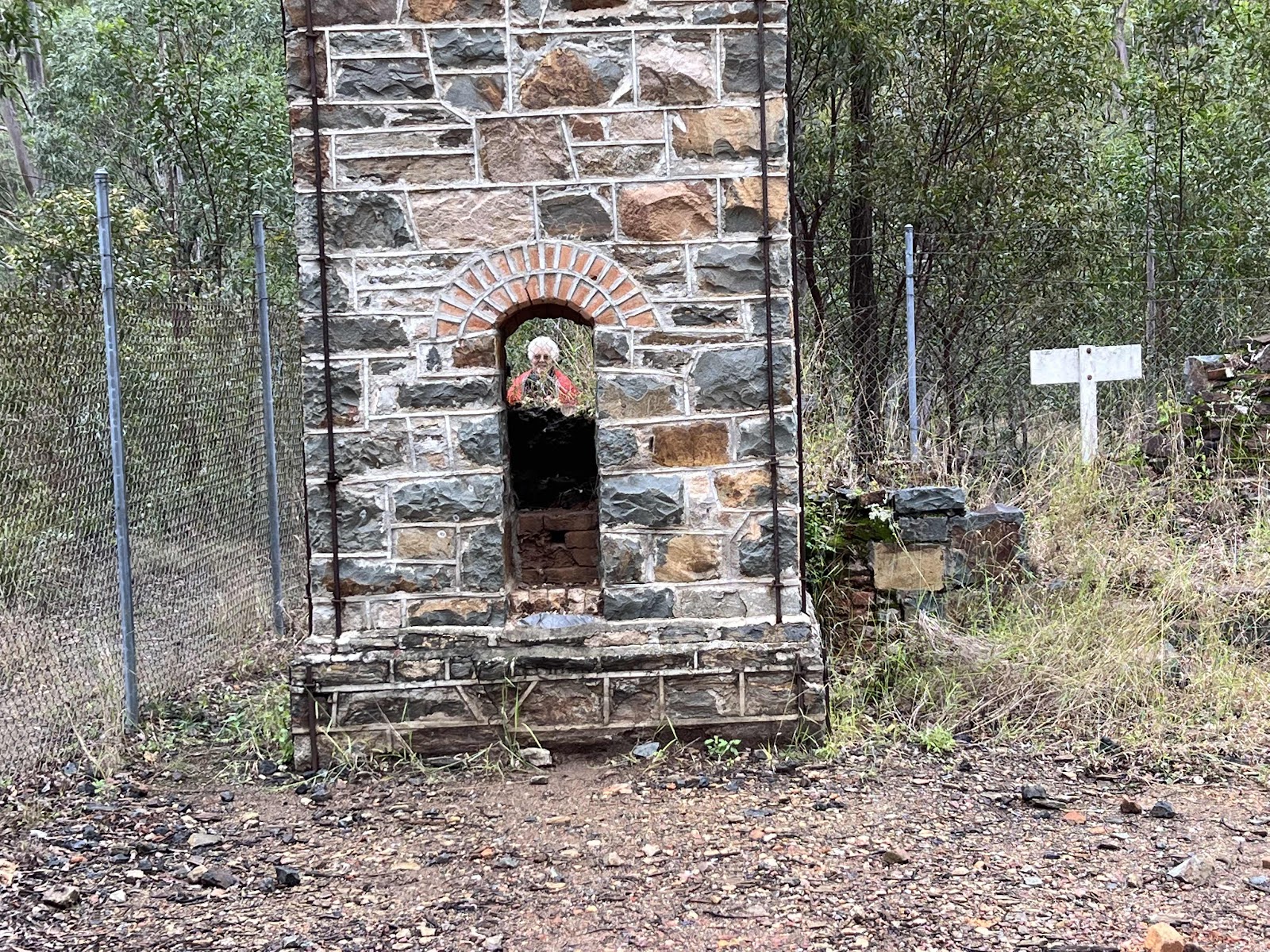
and fortunately at the right place because here was the amazing Chimney structure

A bit of a history on this information board that explains that it was built as a copper smelter, in the late 1800s but in fact wasn’t in use for very long

I tried to take a close up photo of the brickwork but failed miserably.

Bill did a much better job

This shows the incredible brickwork involved and st such a height too

Took photos of the other sections of the operation of the smelter…


Then we both took arty photos of each other

Discovery this pretty creeper on the ground and on the fence

Bill managed a really good photo of the flowers

An exploration of the slag heap didn’t reveal anything of interest

Except interesting formed slag

Back over the creek several times again

We passed this property that is on Hanging Rock Creek which is an offshoot of Fat Hen Creek

I got out of the car to take this photo and got chatting to a man that had just come out of the property with his dog (can just see him in my photo) Turns out the property in on Airbnb and he is just there on holiday

I had seen this, supposed Prophet Mine on the way and was curious to check it out. It was obviously no longer a mine but seemed to be some sort of landscaping supplier but was up for sale

There didn’t seem to be any evidence of any past mining activity but there was this old brick wishing well

The place looked derelict and deserted

Our next place that we had planned to visit was Kinbombi Falls passing through Kilkivan on the way, so we stopped off at Julie’s cafe on the way through

Julie had done a lot of community assistance during the flood, hence received this award

We enjoyed the comfort of the cafe for morning tea

Noticed the furniture in the cafe - same style as in the picnic area at Neureum Creek

On our way past stopped off here to buy a pineapple, some avocados and oranges to support local growers

Next destination Kinbombi Falls

No information here about the walks just about the area. However…
There were plenty of signs at the start and
along the way

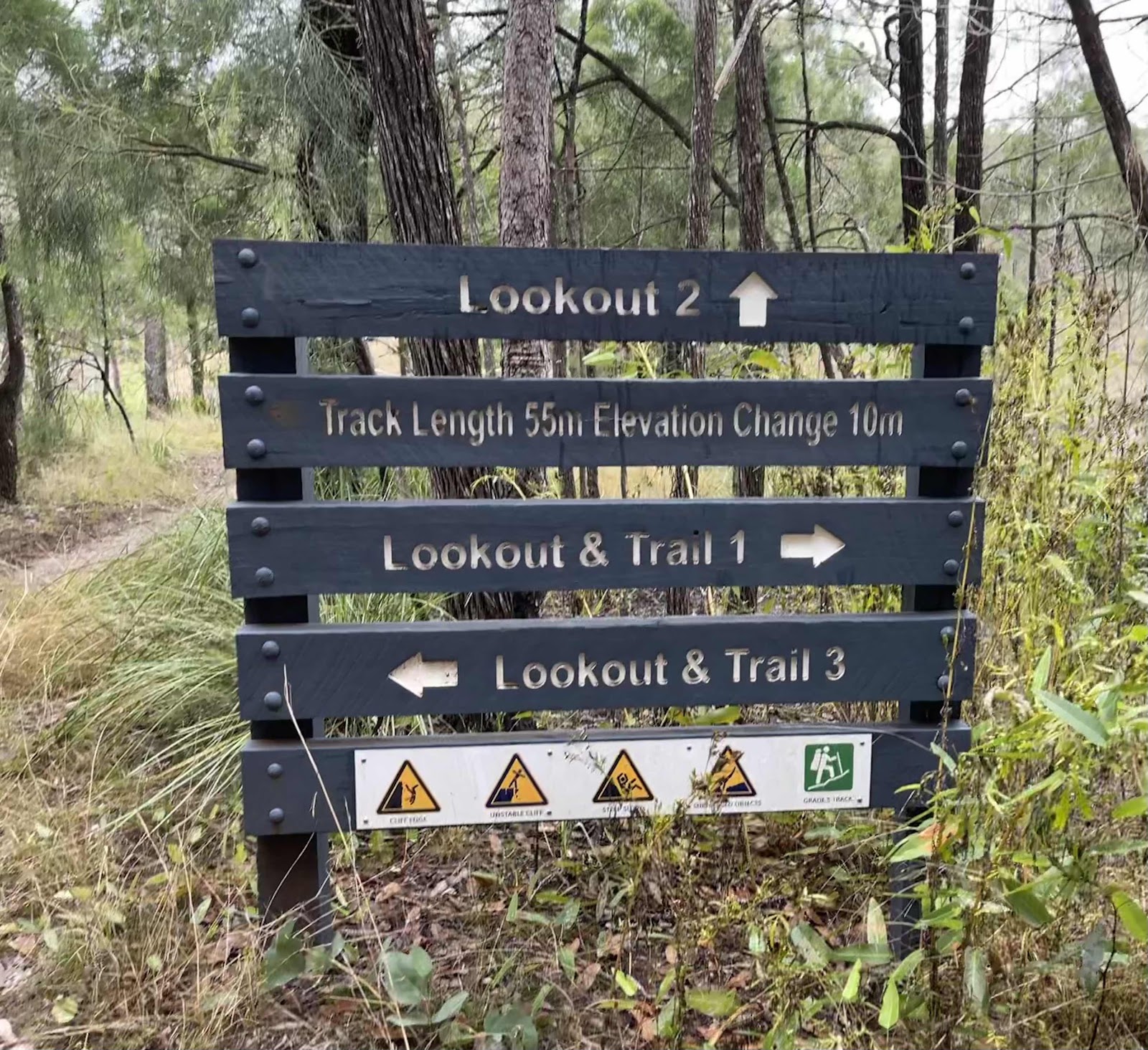
Several trails and lookouts as this map shows, although we did go beyond the trails.

First stop was down a few steps to a view of the falls
This was my view from the platform

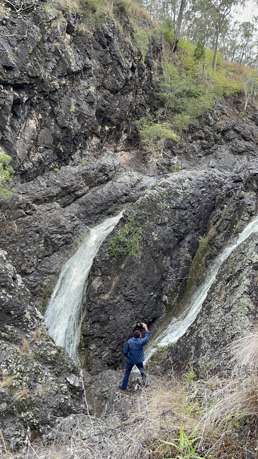
Bill went a bit further and off the track to get a decent view and photo and video

We then walked down the steps to the gorge for this view. Before proceeding on to the lookout that is on the top left of this photo
Took this photo for the interesting rock structure

Bill climbed down over the rocks


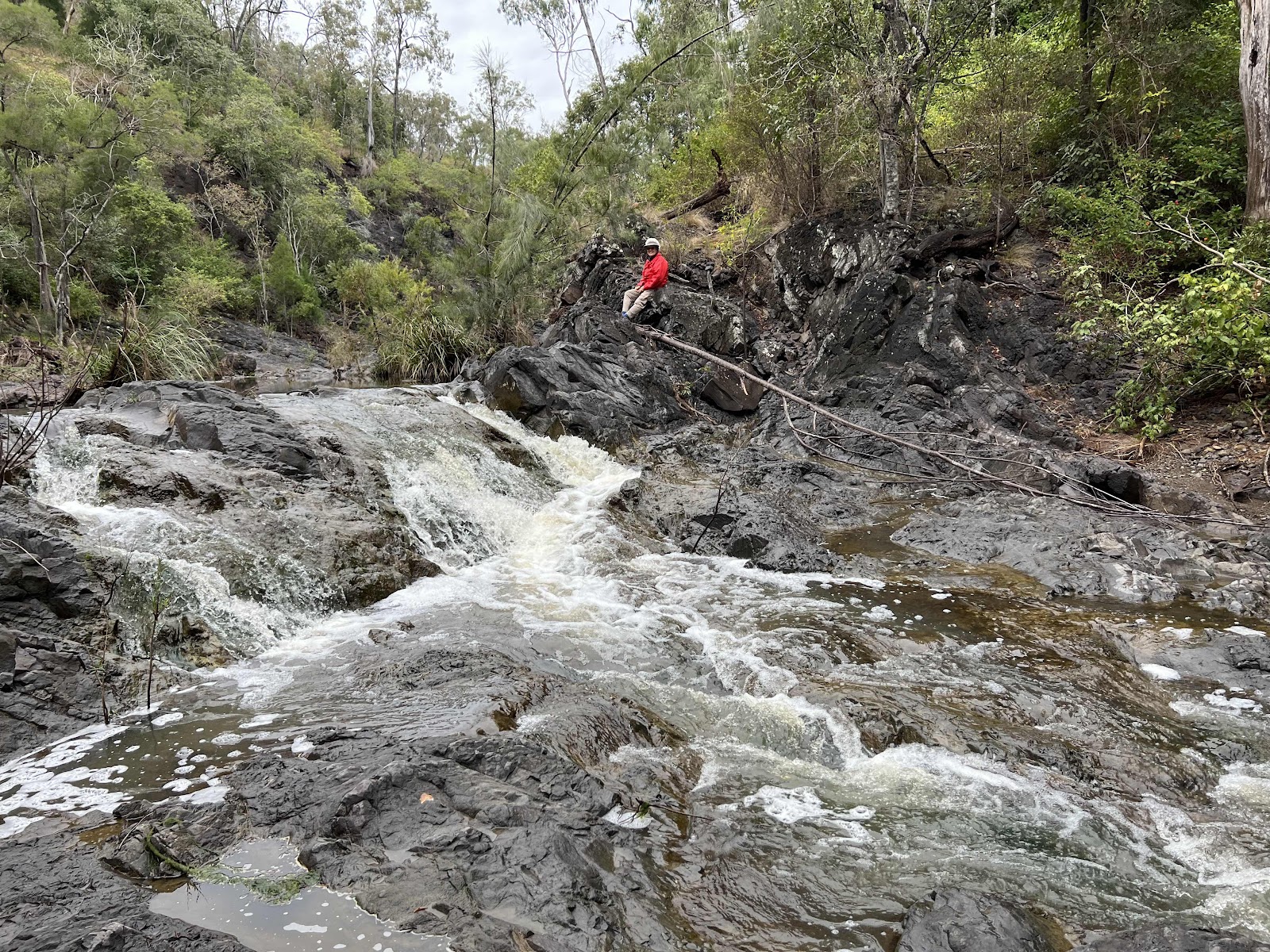
Over to the other side to get a better view of the falls
Sadly they weren’t visible from there

This was his view from the other side, just another trickle of a fall

and me standing there watching

Bill then had to climb back of course

We then had all the steps to go back up


We then followed the path along the top of the ridge to the next lookout

Spotted a rock wallaby hopping across in front of us. Unfortunately it was too quick for me to get a close up

Great views from the other lookout


Could even see the steps that we had gone down previously

and get a close up view of the falls

Bill continued on around and got photos of me at the other lookout


Onto the next lookout


Pretty creeper on the ground

On to the next set of steps down

Most likely the original sign for the steps down

The trail included a section of walk along the edge of the gorge

with views down

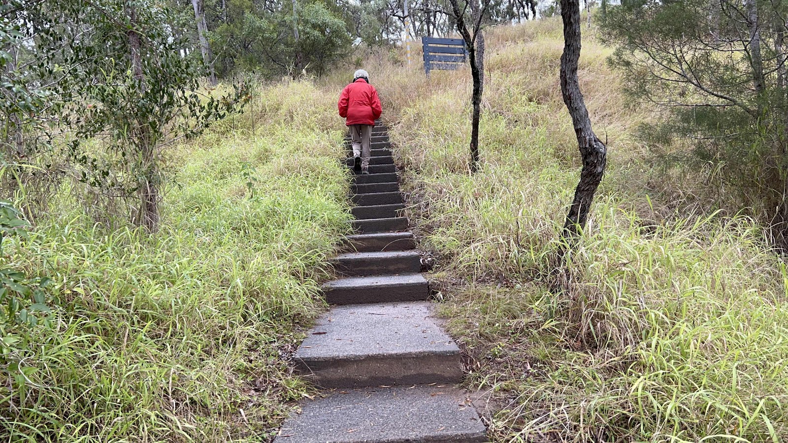
Lots of steps down


and down

and down

Then the path ran out so it was a bit of a scramble to get to the water

which I went down very warily as it was wet and slippery


Bill went on ahead and clambered over the rocks


Whilst I sat and watched

This is now the route back up!!!


A bit wet and muddy at our campsite
A lot of rain around today too
Not to be daunted we still headed out to explore more of the region…
Lots of Roos at the gate of the property on our way out. Stopped to get photos and video of a couple of them scrapping
First stop The Chimney
Lots of things to see on the way too.,.
Fay Hen Creek that we crossed over several times
These cows were walking along beside the fence. There were more that look just the same with the pretty white markings on, that I took video of
I also took video of us splashing through the creek crossings, I did manage to catch the splash on this one through the open window and didn’t get wet
Came across this wash out where a temporary by pass road had been constructed
Finally we reached the end of the navigable road
and fortunately at the right place because here was the amazing Chimney structure
A bit of a history on this information board that explains that it was built as a copper smelter, in the late 1800s but in fact wasn’t in use for very long
I tried to take a close up photo of the brickwork but failed miserably.
Bill did a much better job
This shows the incredible brickwork involved and st such a height too
Took photos of the other sections of the operation of the smelter…
Then we both took arty photos of each other
Discovery this pretty creeper on the ground and on the fence
Bill managed a really good photo of the flowers
An exploration of the slag heap didn’t reveal anything of interest
Except interesting formed slag
Back over the creek several times again
We passed this property that is on Hanging Rock Creek which is an offshoot of Fat Hen Creek
I got out of the car to take this photo and got chatting to a man that had just come out of the property with his dog (can just see him in my photo) Turns out the property in on Airbnb and he is just there on holiday
I had seen this, supposed Prophet Mine on the way and was curious to check it out. It was obviously no longer a mine but seemed to be some sort of landscaping supplier but was up for sale
There didn’t seem to be any evidence of any past mining activity but there was this old brick wishing well
The place looked derelict and deserted
Our next place that we had planned to visit was Kinbombi Falls passing through Kilkivan on the way, so we stopped off at Julie’s cafe on the way through
Julie had done a lot of community assistance during the flood, hence received this award
We enjoyed the comfort of the cafe for morning tea
Noticed the furniture in the cafe - same style as in the picnic area at Neureum Creek
On our way past stopped off here to buy a pineapple, some avocados and oranges to support local growers
Next destination Kinbombi Falls
No information here about the walks just about the area. However…
There were plenty of signs at the start and
along the way
Several trails and lookouts as this map shows, although we did go beyond the trails.
First stop was down a few steps to a view of the falls
This was my view from the platform
Bill went a bit further and off the track to get a decent view and photo and video
We then walked down the steps to the gorge for this view. Before proceeding on to the lookout that is on the top left of this photo
Took this photo for the interesting rock structure
Bill climbed down over the rocks
Over to the other side to get a better view of the falls
Sadly they weren’t visible from there
This was his view from the other side, just another trickle of a fall
and me standing there watching
Bill then had to climb back of course
We then had all the steps to go back up
We then followed the path along the top of the ridge to the next lookout
Spotted a rock wallaby hopping across in front of us. Unfortunately it was too quick for me to get a close up
Great views from the other lookout
Could even see the steps that we had gone down previously
and get a close up view of the falls
Bill continued on around and got photos of me at the other lookout
Onto the next lookout
Pretty creeper on the ground
On to the next set of steps down
Most likely the original sign for the steps down
The trail included a section of walk along the edge of the gorge
with views down
Lots of steps down
and down
and down
Then the path ran out so it was a bit of a scramble to get to the water
which I went down very warily as it was wet and slippery
Bill went on ahead and clambered over the rocks
Whilst I sat and watched
This is now the route back up!!!
the steep incline, making sure not to slip

Then all the steps back up


Pretty bark on this tree


 Spent ages here as is evident by all the photos
But time to move on
Then all the steps back up
Pretty bark on this tree
Spent ages here as is evident by all the photos But time to move on
We decided that on Ina’s advice to go a little way along Running Creek Road , past the turn off into the property.

The mountain at Mudlo on our left in the distance

Lots of cows meandering along and crossing in front of us

Lots of creek crossings again

Crossing Wide Bay Creek many times


We ended up continuing along Running Creek Road to the end

We hadn’t really planned on going the whole way but we did in the end. Ended up on the Bauple Woolooga Rd

Passing through Woolooga


Eventually junctioning with the Wide Bay Highway

This was our days journeys mapped with Hema maps

Great day out
The mountain at Mudlo on our left in the distance
Lots of cows meandering along and crossing in front of us
Lots of creek crossings again
Crossing Wide Bay Creek many times
We ended up continuing along Running Creek Road to the end
We hadn’t really planned on going the whole way but we did in the end. Ended up on the Bauple Woolooga Rd
Passing through Woolooga
Eventually junctioning with the Wide Bay Highway
This was our days journeys mapped with Hema maps
Great day out
Finally got to have a very late lunch cum early dinner - very yummy red empiror with veggies and a cauliflower cheese sauce

Followed by port and chocolate

Followed by port and chocolate

Looks like you had a great day. Happy Independence Day Bill. What ever that is. you are still married so it couldnt be that !!
ReplyDeleteIt is the day that Bill finished work.
DeleteHe chose to leave on American Independence Day!!!!!